The world's combined global land and ocean surface temperature made last month the warmest March on record, according to NOAA. Taken separately, average ocean temperatures were the warmest for any March and the global land surface was the fourth warmest for any March on record. Additionally, the planet has seen the fourth warmest January -- March period on record.
The monthly National Climatic Data Center analysis, which is based on records going back to 1880, is part of the suite of climate services NOAA provides government, business and community leaders so they can make informed decisions.
The combined global land and ocean average surface temperature for March 2010 was the warmest on record at 56.3°F (13.5°C), which is 1.39°F (0.77°C) above the 20th century average of 54.9°F (12.7°C).
The worldwide ocean surface temperature was the highest for any March on record --1.01°F (0.56°C) above the 20th century average of 60.7°F (15.9°C).
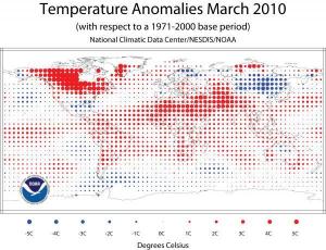
Temperature anomaly is the difference from average, which gives a more accurate picture of temperature change. In calculating average regional temperatures, factors like station location or elevation affect the data, but those factors are less critical when looking at the difference from the average. (Credit: NOAA/National Climatic Data Center/NESDIS)
Separately, the global land surface temperature was 2.45°F (1.36°C) above the 20th century average of 40.8 °F (5.0°C) -- the fourth warmest on record. Warmer-than-normal conditions dominated the globe, especially in northern Africa, South Asia and Canada. Cooler-than-normal regions included Mongolia and eastern Russia, northern and western Europe, Mexico, northern Australia, western Alaska and the southeastern United States.
El Niño weakened to moderate strength in March, but it contributed significantly to the warmth in the tropical belt and the overall ocean temperature. According to NOAA's Climate Prediction Center, El Niño is expected to continue its influence in the Northern Hemisphere at least through the spring.
For the year-to-date, the combined global land- and ocean-surface temperature of 55.3°F (13.0°C) was the fourth warmest for a January-March period. This value is 1.19°F (0.66°C) above the 20th century average.
According to the Beijing Climate Center, Tibet experienced its second warmest March since historical records began in 1951. Delhi, India also had its second warmest March since records began in 1901, according to the India Meteorological Department.
Other Highlights
Arctic sea ice covered an average of 5.8 million square miles (15.1 million square kilometers) during March. This is 4.1 percent below the 1979-2000 average expanse, and the fifth-smallest March coverage since records began in 1979. Ice coverage traditionally reaches its maximum in March, and this was the 17th consecutive March with below-average Arctic sea ice coverage. This year the Arctic sea ice reached its maximum size on March 31st, the latest date for the maximum Arctic sea ice extent since satellite records began in 1979.
Antarctic sea ice expanse in March was 6.9 percent below the 1979-2000 average, resulting in the eighth smallest March ice coverage on record.
In China, the Xinjiang province had its wettest March since records began in 1951, while Jilin and Shanghai had their second wettest March on record. Meanwhile, Guangxi and Hainan provinces in southern China experienced their driest March on record, according to the Beijing Climate Center.
Many locations across Ontario, Canada received no snow, or traces of snow, in March, which set new low snowfall records, according to Environment Canada.
Scientists, researchers, and leaders in government and industry use NOAA's monthly reports to help track trends and other changes in the world's climate. This climate service has a wide range of practical uses, from helping farmers know what and when to plant, to guiding resource managers with critical decisions about water, energy and other vital assets.
Story Source:
Adapted from materials provided by National Oceanic And Atmospheric Administration.
(The Center for Earth Observation and Digital Earth, The Lanzhou Branch of the National Science Library / The Scientific Information Center for Resources and Environment) |