Researchers at the Institute of Geodesy and Geophysics at Vienna University of Technology (TU) are investigating the effects of the Earth's atmosphere on our planet's shape, its rotation and its gravitational field.
A new research project investigates how Earth's atmosphere affects our planet's shape, its rotation and its gravitational field.
The Earth's atmosphere is not only essential to support human life on Earth; it also affects our planet's shape, its rotation and its gravitational field. The research project "Global Geodetic Observing System (GGOS) Atmosphere" is a comprehensive and cross-disciplinary study of these complex interrelationships, financed by the Fonds zur Förderung der wissenschaftlichen Forschung (FWF) [The Austrian Science Fund]. The researchers' aim is to develop a better understanding of the Earth's system and to support the development of the Global Geodetic Observing System (GGOS).
The Earth's pulse
Many different atmospheric influences have to be taken into consideration in modern geodesy, particularly when using space-geodetic techniques. The atmosphere delays radio signals from GPS satellites as well as signals from extragalactic radio sources, which are monitored using the VLBI (Very Long Baseline Interferometry) technique. Atmospheric loads (= air pressure), e.g. during a high pressure weather system, can change the shape of the elastic Earth by up to two centimetres and can also alter the Earth's gravitational force. Data from observations of the Earth's gravitational field -- e.g. collected using special satellite missions -- must, therefore, be adjusted to account for atmospheric influences. Atmospheric processes are also a significant cause of small, but measurable fluctuations in the Earth's rotation pattern, which can be seen from polar motion and changes in length of day.
Global monitoring and networking
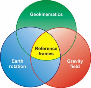
The atmosphere, therefore, has a significant role to play in the development of the "Global Geodetic Observing System (GGOS)" by the International Association of Geodesy (IAG), the main purpose of which is to research "Global deformation and mass movements in the Earth's system." Around the world, hundreds of geoscientists are working on the GGOS, which aims to combine and integrate the diverse geodetic and geophysical data currently being collected both on Earth and in space. As TU researcher Johannes Böhm explains: "Only in this way will we be able to draw conclusions which are really relevant for society, like evidence for climate research or predictions for natural disasters." Precise, global reference points are essential for the Global Geodetic Observing System. Only once a stable, highly accurate and global set of fixed reference points has been established, can gradual changes, such as the movement of tectonic plates or sea level changes, be measured accurately.
Meteorological data for geodynamic parameters
The main aim of the "GGOS Atmosphere" project is to develop consistent and homogeneous models for (1) the effects of atmospheric pressure loading, (2) atmospheric angular momentum functions and (3) the coefficients of the atmosphere's gravitational potential, from a collective data set. The same meteorological parameters, including air pressure, temperature, humidity and wind speed, are used for all models. The data used is from the European Centre for Medium-Range Weather Forecasts (ECMWF) and has the highest possible spatial and temporal resolution.
The effects of different ECMWF data categories and different geophysical models on the three aforementioned phenomena will be investigated. Once the most suitable categories and models have been found, the Institute of Geodesy and Geophysics will calculate the effects of atmospheric pressure loading, angular momentum functions and the coefficients of the atmosphere's gravitational potential for the entire time period for which there are space-geodetic observations. They will then make their results available to the international scientific community. The findings from this research project will increase our understanding of the Earth's system, giving us a cross-disciplinary understanding of the interrelationships between the Earth's different components (i.e. solid earth, oceans and atmosphere) as well as of the related changes to the Earth's geometry, rotation and gravitational field.
Source:http://www.sciencedaily.com/releases/2010/03/100308203308.htm
(The Center for Earth Observation and Digital Earth, The Lanzhou Branch of the National Science Library / The Scientific Information Center for Resources and Environment,Chinese Academy of Sciences)