The European Commission Joint Research Centre (JRC), the Food and Agriculture Organization of the United Nations (FAO) and the American Famine Early Warning Systems Network (FEWS NET) are working to innovate and reinforce their food security monitoring systems and to develop more efficient early warning tools. These efforts come as a response to the 2007-2008 global food crisis that increased significantly the number of countries under threat of famine.
Satellite observation is the key instrument that will allow to double in 2010 the number of countries monitored in real time for detecting first indications of adverse agricultural outcomes. The new Integrated Phase Classification (IPC) system facilitates and accelerates the reaction time to food security crises by allowing a common and internationally recognised classification of their severity.
According to the Food and Agriculture Organization, more than 1 billion people go to bed each night with an empty stomach. In addition, the latest global food crisis resulted in more countries being added to the list of food insecure populations. This is probably the most urgent and dramatic problem that humankind faces today. Food security is not only a crucial issue for developing countries and their more vulnerable inhabitants; it is also key to building a more stable, equal, wealthier and safer world.
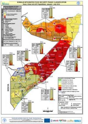
Somalia's Integrated Food Security Phase classification map. (Credit: Image courtesy of European Commission Joint Research Centre)
Special programmes are run and significant funds are mobilised every year by the international community in an effort to combat the increasing number of food insecure populations. Identifying the times and places where aid is required is crucial to deliver targeted and effective responses. Here is where the scientific community comes into play by developing methodologies and tools to provide timely information and objective assessments of the food requirements, thus supporting the decision-making process with solid evidence.
The power of satellite imagery
Several organisations dealing with food security both in Europe and in the United States traditionally rely on satellite observations to support their assessment activities. As a consequence of the alarming spike in global food prices in 2008, many more countries are potentially threatened by food insecurity and need to be constantly monitored in order to detect early signs of adverse agricultural conditions. Satellite-based forecasting systems will therefore take on increased importance in the next years, allowing organisations to monitor a larger number of countries than it is currently possible to do with in-country offices.
The Joint Research Centre (JRC) will extend this year the real time monitoring system it has developed to forecast food crises. It will cover not only the Horn of Africa, but all the most food insecure countries in Sub-Saharan Africa. As the earth observation and agroclimatic data regularly received by the JRC are global, other countries outside Africa can also be monitored in case of food security crises.
This JRC operational system for regional crop monitoring and forecasting is based on satellite data and innovative agro-climatic models. More than 40 regional bulletins provide each year quantitative and qualitative yield forecasts for food insecure countries around the world, with a particular emphasis in Africa. In 2009, JRC provided for instance an early warning of the drought affecting Kenya, and correctly predicted a 15% below average maize yield one month before harvest.
In the United States, the Famine Early Warning Systems Network (FEWS NET) will extend this year its food security monitoring system from the current 20 to 50 additional countries around the world. The US Geological Survey (USGS), the National and Oceanic Atmospheric Administration (NOAA), and the National Aeronautics and Space Administration (NASA) are establishing expedited procedures for processing of satellite data and model runs to support FEWSNET in this task.