A major 7.0-magnitude earthquake struck the Haitian capital of Port-au-Prince on 12 January, causing major casualties and damage. The quake was followed by several aftershocks with magnitudes over 5.0.
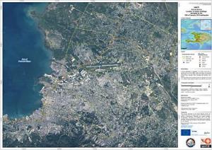
Satellite map over the Port-au-Prince area of Haiti acquired on 13 January 2010, following a 7.0 magnitude earthquake and several aftershocks that hit the Caribbean nation on 12 January. (Credit: SERTIT - CNES - International Charter)
Such a powerful earthquake can make current maps suddenly out of date, causing additional challenges to rescue workers on the ground. Earth observation satellite images can help rescue efforts by providing updated views of how the landscape and the infrastructure have been affected.
Following the event, the French Civil Protection authorities, the Public Safety of Canada, the American Earthquake Hazards Programme of USGS and the UN Stabilisation Mission in Haiti requested satellite data of the area from the International Charter on 'Space and Major Disasters'. The initiative, referred to as 'The Charter', is aimed at providing satellite data free of charge to those affected by disasters anywhere in the world.
To meet the requirements of the rescue teams in Haiti, Very High Resolution imagery is needed from both optical and radar sensors. Through the Charter, the international space community is acquiring satellite imagery as quickly as possible. Currently, data are being collected by various satellites including Japan's ALOS, CNES's Spot-5, the U.S.'s WorldView and QuickBird, Canada's RADARSAT-2 and ESA's ERS-2 and Envisat.
Satellite imagery acquired immediately after the event are used to generate emergency maps to provide rescue services with an overview of the current state of the area. These can be compared with situation maps generated from archived satellite data to identify major changes on the ground caused by the disaster.
Comparison of the maps from before and after the event allows areas that have been hit hardest to be distinguished and identify passable routes for relief and rescue workers. Additionally, they can help to identify areas which are suitable for setting up aid camps where medical support and shelter can be provided to people.
Radar satellites are able to peer through clouds, which is an asset when weather conditions prevent the use of optical satellite instruments. Radar imagery can be used to identify hazards such as landslides that may be triggered by earthquakes. In the long term, radar data can also be processed to map surface deformations caused by earthquakes to help scientists understand better seismic events.
Source:http://www.sciencedaily.com/releases/2010/01/100114143323.htm
(Information provided: The Center for Earth Observation and Digital Earth, The Lanzhou Branch of the National Science Library / The Scientific Information Center for Resources and Environment CAS)
|