Soon after a magnitude 8.0 earthquake struck Wenchuan in southern China’s Sichuan Province on May 12, 2008, RADI conducted monitoring and assessment of the damages caused by the disaster with remote sensing, providing important support to decision-making on disaster relief and post-quake construction. In later years, from 2008 to 2013, to have a comprehensive understanding of its aftermath, changes, and reconstruction and provide scientific evidence for post-quake development, RADI carried out flight experiments for continuous and dynamic aerial monitoring with remote sensing in the region. In April 2013, on the eve of the fifth anniversary of the deadly catastrophe, RADI carried out its fifth flight experiment.
Covering major quake-affected areas, including Wenchuan, Beichuan, Anxian, Shifang, Dujiangyan, Wolong, and the Minjiang River Basin, this experiment could supply basic data for research and policymaking concerning the assessment of post-quake changes and construction. Aboard the B-4101 Citation remote sensing airplane of the CAS Center for Airborne Remote Sensing was an ADS80 push-broom digital camera, which could provide better than 0.4 meter resolution for data acquisition, and ALS70 airborne laser radar.
To ensure the efficient performance of the test, headquarters were set up at RADI with Director-General GUO Huadong as its leader to coordinate data acquisition, processing, and liaison tasks. Under the head offices, there were eight taskforces to carry out remote sensing experiments on a variety of subjects, including geological hazards, housing and urban development, road building, rivers and barrier lakes, agriculture and forest recovery, eco-environment (including giant panda sanctuaries), major engineering projects, and digital Beichuan.
Based on ample data and findings from the five experiments, RADI researchers produced 20 reports to comprehensively evaluate different topics ranging from major landslides, debris flows, and engineering projects for defusing barrier lake dangers to farmland and ecological recovery and town reconstruction. The team provided direct scientific evidence to show the progress of post-quake reconstruction.
1. Major landslide and debris flow hazards
Using aerial images taken during the period between 2008 and 2013, dynamic monitoring and assessment were conducted on the evolution of major landslide bodies and debris flows, and ecological recovery in the quake-hit region.
(1)Intensive landslides have occurred frequently over the past five years. New debris flows covering an area of 418.66 hectares have been discovered nearby 13 large landslide clusters, accounting for 8.8% of the total. However, as shown by Table 1, the activity of debris flows tends to be decreasing year by year.
(2) There has been a gradual vegetation recovery on the sliding bodies of landslide clusters caused by the earthquake. The recovery rate registered 9.01% for the first year after the disaster and 6.54% on average annually over the past five years.
(3) Nine places with risks of secondary geological hazards posing a threat to buildings have been found in Wenchuan, as shown in Figure 1.
(4) The vegetation recovery process was very slow on the two largest landslide bodies in Anxian County and Mianzhu City over the five years with recovery rates of 2.3% and 8.9%, respectively. Potential risks of secondary hazards in the areas are high, as shown in Figure 2.
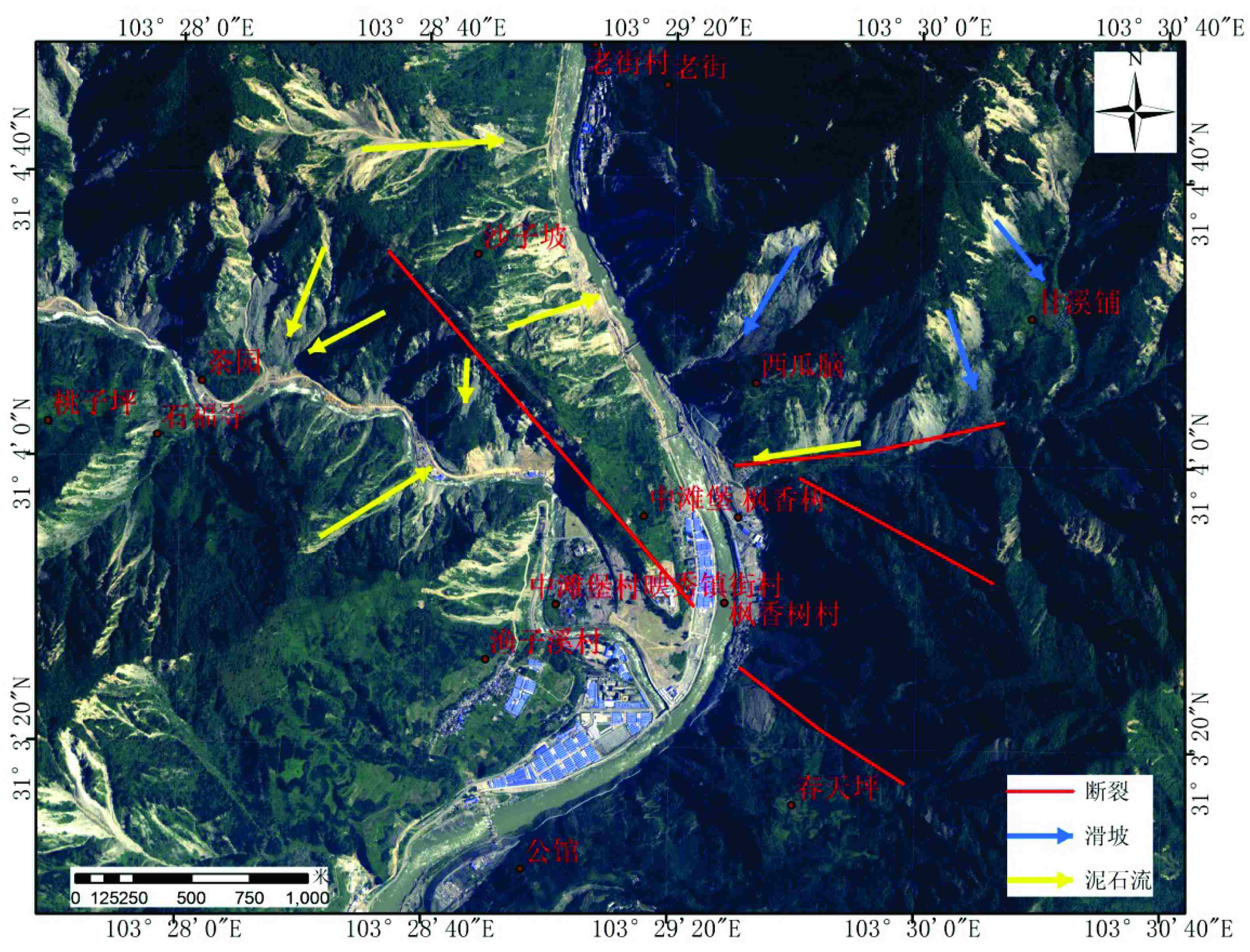 Figure 1 Maps showing geological hazard risks in Yingxiu Township.
The yellow arrow shows debris flows, blue shows landslides, and red lines show the geological tectonic structure. There are at least seven places with deposited materials for potential debris flows and corresponding gullies on both sides at the upper reaches of Yingxiou. In addition, as shown by the blue arrow, landslide bodies in the region, especially those nearby the Minjiang River, feature a large area, huge volume, and loose layers. The debris flow deposits and landslide bodies consist of source material for new debris flows. Once a heavy rain occurs, it is easy for them to form barrier lakes, threatening the lower reaches of the region. Last but not the least, as an integration of many fracture belts (as shown by thick lines in red), the region, subject to tectonic landform activities, is unstable with huge potential for hazards.

Figure 2. An aerial interpretation of a region with large landslide bodies in Wenjiagou of Mianzhu City.
Deformation rate of Zipingpu reservoir dam and neighboring slope bodies with unstable and bare soil surface (2008-2010). The image shows the deformation rate of the dam is about 5-7 millimeters per year.
2. Engineering projects to eliminate risks of barrier lakes
Dynamic monitoring of 36 barrier lakes in 70% of the quake-ravaged region shows that tremendous achievements have been scored in this regard over the past five years, defusing almost all risks. No newly created barrier lakes have been found. For those lakes that have not been completely dredged, their volume has been effectively reduced and their dam bodies have been strengthened as a result of man-made reinforcement, dredge projects, or natural scour. They have become important natural legacies and scenic sites, such as the huge Tangjiashan earthquake lake.
 Figure 3. An aerial remote sensing image of Tangjiashan Quake Lake in 2013. With a volume of 6,443 cubic meters, it has become an important scenery site caused by the earthquake.
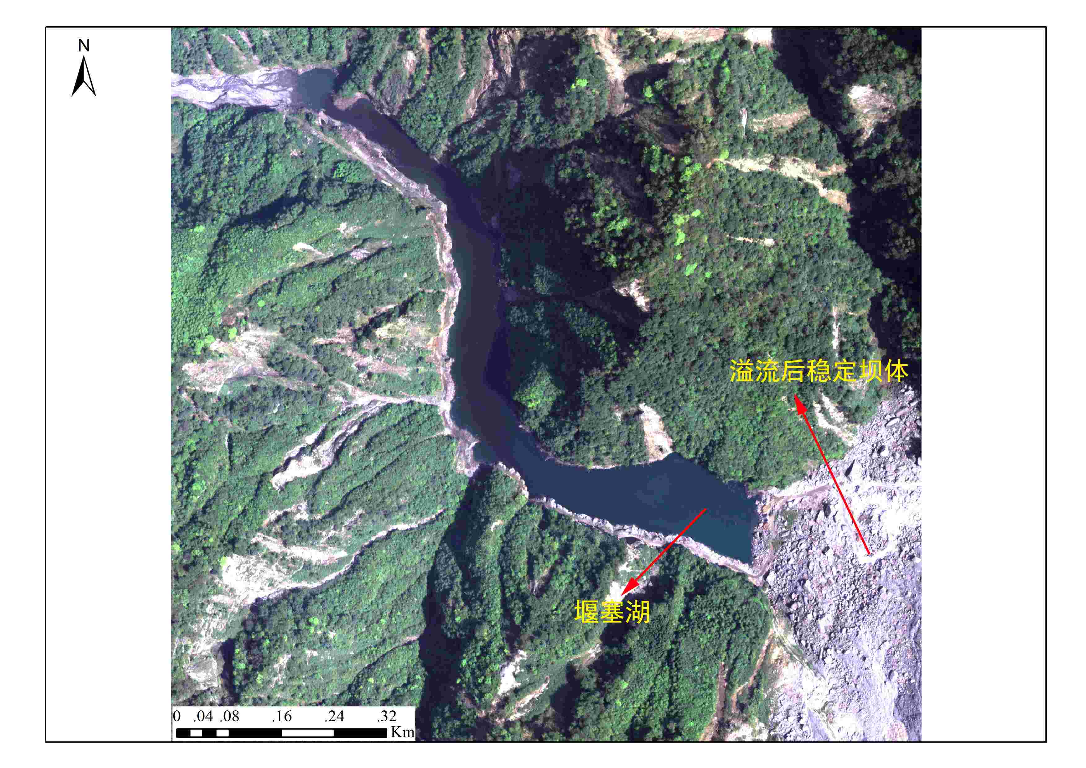 Figure 4. An aerial remote sensing image of Changheba Quake Lake, showing its volume has been effectively reduced, therefore becoming a solid medium-sized quake lake.
3. Farmland recovery
Land damage and its recovery was analyzed on the basis of dynamic monitoring of the 12 worst-hit counties and cities. Only 20% of the farmlands ruined by landslides or debris flows have been recovered and used for planting. Because of the high utilization rate of arable lands and enthusiasm of the farmers, there is almost no fallow or waste land except ruined ones. There is no big change in local planting structures, patterns, and habits. There is a slight increase in the planting area of cash crops at the cost of food crops.
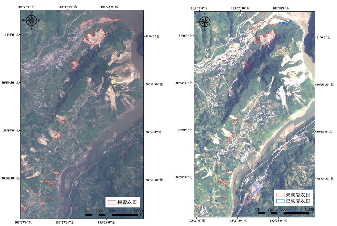 Figure 5. Information about farmland damages and recovery in regions nearby Xuankou Township, Wenchuan, from 2008 to 2013.
4. Vegetation recovery
The earthquake and its secondary disasters did huge damage to the local vegetation. Dynamic monitoring from 2007 to 2011 shows:
(1) Its vegetation coverage was reduced by 6.5%. However, 4.4% had been recovered by 2011, accounting for 68% of the total lost. In addition, the situation is better in the eastern and northern parts.
(2) Forest resources in the arid valley of the Minjiang River and Penzhoushan region were damaged worst by the earthquake. Five years later, shrubs and broad-leaved tree seedlings have started growing there. Through both setting apart hills for tree growing and forest plantation, the vegetation recovery process has been faster in Penzhoushan than in the arid valley.
(3)The earthquake has caused ecological degradation and scenery fragmentation in the Wolong National Nature Reserve. Analysis of multi-source images shows that, thanks to natural recovery and the program for ecological reconstruction, the vegetation of the habitat for giant pandas has reached the pre-quake level in terms of area and canopy coverage. The quality of its ecological system has improved, and the habitat and corridors for exchanges of giant pandas have been restored.
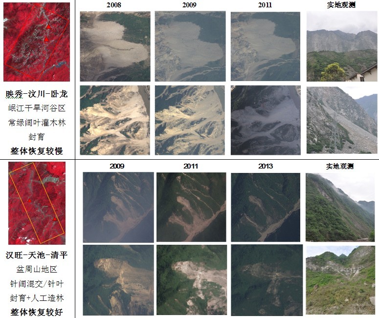
Figure 6. Vegetation comparison in typical regions of the Wolong National Nature Reserve.
5. Post-quake town reconstruction
Huge progress has been made in terms of urban rebuilding in 12 townships in Beichuan over the past five years. Temporary shelters in the wake of the earthquake have been dismantled. The urban rebuilding program was completed in 2011 with improved infrastructure, such as roads with a more rational layout and schools. The overall ecological conditions have been greatly upgraded with normal transport by road and rivers.
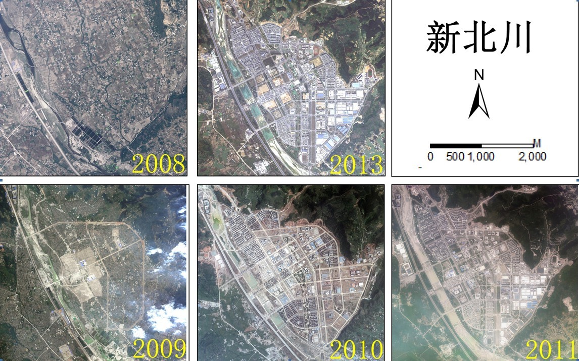
Figure 7. Changes in the Earth’s surface in the county seat of Beichuan over the past five years: a sparse rural residency area has become a modern urban area.