The Division of Geo-Graphic Analytics of Remote Sensing from RADI, led by Prof. GONG Jianhua and Prof. LUO Jiancheng, has recently completed the prototype design and experimental evaluation of the UAV-borne multi-camera system (MCSystem) for oblique image acquisition and eventually for 3D city reconstruction. Two field campaigns in Suzhou, Jiangsu Province and Jiashan, Zhejiang Province have been successfully finished to demonstrate the potential of the MCSystem for 3D city reconstruction.
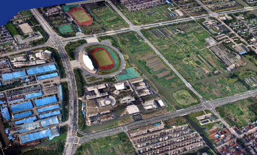
The MCSystem is designed to accurately retrieve the geometrical shapes and textures of urban built-up areas through the capturing of all exposed building surfaces, which would not normally be fully visible to the traditional orthogonal cameras. In smart city development, 3D city reconstruction is commonly performed to lay the foundation for geospatial database construction. Therefore, the MCSystem will play a major role in transforming the current “digital cities” to “smart cities” in China. The recent experimental flights have been focused on two leading cities in the smart transformation movement. The research team used MCSystem to survey 5 km2 of the Suzhou Hi-tech Zone (SND) on August 3. Then, in cooperation with the Zhejiang-CAS Spatial Information Technology Application Center, the team reconstructed 15 km2 of urban building models based on the UAV oblique images on September 5.
In addition to the efficient data acquisition and processing, geospatial data sharing and publishing also forms an important cornerstone of the foundation of smart city development. At a routine meeting of the project “Geospatial Information System for Global Environments and Resources” held on September 12, the joint research team of Prof. Gong and Prof. Luo proposed to use WebGL and cloud computing to publish the oblique photogrammetry-based 3D cities. According to the proposed idea, Level-of-Details (LOD) models will be generated for an enormous amount of geometrical and textural contents to enable web explorer-based progressive data streaming and refinement.

UAV oblique imagery-based 3D modeling of Suzhou Hi-tech Zone (SND) for the local smart city development.
Using UAV oblique imagery-based 3D reconstruction to facilitate the urban flood risk management in Jiashan, Zhejiang province.