Started in April this year and lasting more than 4 months, a comprehensive Experiment on the full-band multi-scale remote sensing mechanism was completed recently, of which the part organized by RADI was completed on August 24 at the Huailai Remote Sensing Experiment Site, with all pre-set objectives successfully fulfilled.
The comprehensive experiment was designed and carried out by the State Key Laboratory of Remote Sensing Science in conjunction with related research institutions. The objectives of the experiment are to measure the radiation and scattering characteristics of full-band multi-scale remote sensing, obtain an associated dataset, and verify the radiation and scattering model of full-band remote sensing, so as to provide a real scene and data basis for the development of a full-band multi-scale remote sensing simulation system.
Experiments at the Huailai Site lasted more than 4 months, involving over 3000 times of tests by persons from nearly 10 research institutions. The ground-based observation experiment was commenced from the bare-soil period in April and observation was made throughout the entire growing period of wheat. Full-growing-period observation was also carried out for corn, which lasted from May till the filling stage was over in August. Ground-based observation was made mainly by means of automatic equipment, supplemented by artificial observation, to measure leaf area index, soil moisture content, vegetation height, surface temperature, evapotranspiration rate and other parameters. Intensified and continuous observation was performed in key areas.
Airborne remote sensing experiments were made from July 15 to August 10. For the first time, two remote sensing airplanes of RADI, one optical and other micro-wave, were used to actively and passively observe the same survey area simultaneously. The optical one was equipped with Lidar and an infrared remote sensor, and the microwave one was carrying C-band radar, P-band radar and L-band radar, all of which were developed and manufactured by the Institute of Microelectronics, CAS. The two airplanes completed a total of 11 sorties. Satellite data, including optical, infrared and microwave data ranging from meter-scale to km-scale, were collected throughout the test period.
Making full use of the Huailai Site’s experimental conditions such as the tall steel towers, the elevated vehicles, the mobile observation cars and other platforms, the researchers performed long-time-sequence full-band coordinated active and passive comprehensive observation of corn, bare soil, platycladus orientalis and other targets by means of remote sensing, and innovations were made in tower-base multi-angle observation system integration, UAV-based imaging spectral observation and the method of measuring the dielectric constant of vegetation leaves. In the experiment, RADI’s aerial remote sensing facilities and satellite data receiving station were fully utilized, the remote sensing mechanism was thoroughly studied, and spaceborne-airborne-ground collaborative observation was realized.
The data collected through the experiment will be conducive to the construction of the full-band model platform of the State Key Laboratory of Remote Sensing Science, and provide a basis for the study of radiation transfer, the active and passive collaborative inversion of remote sensing parameters, and the authenticity validation of remote sensing data products. All experimental data are being processed and will be open to both domestic and foreign researchers.
In the past few years the State Key Laboratory of Remote Sensing Science, in cooperation with related research institutions, has been working on a major scientific program “Earth System Comprehensive Remote Sensing Observation and Simulation”, which is focused on two core tasks: R&D of a full-band multi-scale remote sensing model platform and that of a global multi-scale quantitative remote sensing product production system. The aforesaid experiment was designed and implemented to accomplish the two tasks.
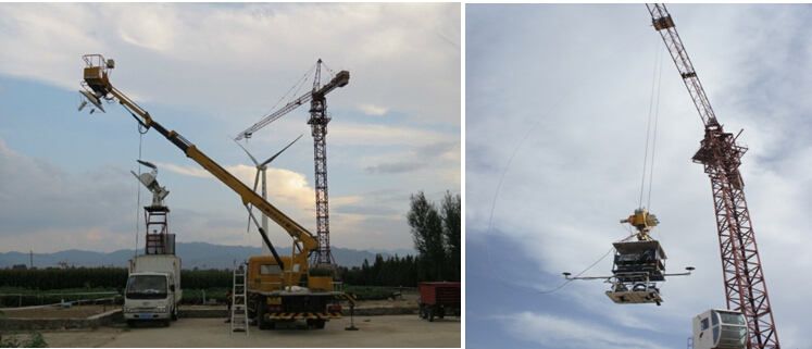
Multiple platforms in operation.
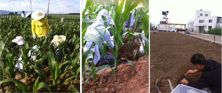
Simultaneous observation of ground parameters.

A scene from the experiment.