The "Belt and Road" International Training Workshop on Strengthening Science Capacities for Sustainable Development and Disaster Risk Reduction was successfully kicked off in the Sanya Campus of the Institute of Remote Sensing and Digital Earth (RADI) of the Chinese Academy of Sciences (CAS) on November 28. The event was co-organized by the “Digital Belt and Road” Initiative (DBAR), CAS-TWAS Centre of Excellence on Space Technology for Disaster Mitigation (SDIM), Integrated Research on Disaster Risk (IRDR) International Programme Office (IPO), IRDR China National Committee (IRDR CHINA), Institute of Remote Sensing and Digital Earth (RADI), International Council for Science World Data System (ICSU-WDS), and International Society for Digital Earth (ISDE).
The workshop centered on disaster risk reduction in developing countries along the Belt and Road, and combined theories, methods and practices within the framework of the "Digital Belt and Road" (DBAR) to improve the capacities of young scholars and management staff from relevant countries for sustainable disaster risk reduction. More than 20 trainees attended the workshop from 15 developing countries, including Bangladesh, Myanmar, Pakistan, Thailand, Mongolia, Malaysia, Sri Lanka, Vietnam, India, and Morocco.
Academician GUO Huadong, Director of SDIM, HU Changyou, Deputy Secretary General of the Sanya Government, FENG Kai, Deputy Director of the Division of International Organizations of the CAS Bureau of International Cooperation, Rajib Shaw, Executive Director of the IRDR International Programme Office, WANG Changlin, Executive Director of ISDE, and other guests attended the opening ceremony and delivered speeches. CHEN Feng, Executive Deputy Director of SDIM, chaired the opening ceremony.
GUO Huadong pointed out that the "Belt and Road" stretches across the African and Eurasian continents and involves a number of countries and regions in the Central Asia economic belt, the Central Asia Rim economic belt, and the Asia-Europe economic belt. The regions along the Belt and Road feature complex terrains and climates, and are exposed to the risk of earthquakes, droughts, floods, typhoons and other natural disasters, with the resulting economic losses rising every year. Scientific responses to disaster risks are one of the six major themes of DBAR. International cooperation in disaster risk reduction not only helps enhance the capacity of countries along the Belt and Road for scientific disaster risk reduction, but greatly contributes to the implementation of the UN Sendai Framework for Disaster Risk Reduction: 2015-2030 in relevant countries.
HU Changyou said that Sanya, an important city in the southernmost area of China, plays a crucial role in China’s march towards national scientific and technological innovation. This international training workshop is an important part of the sci-tech cooperation for disaster reduction supported by CAS under the framework of the Belt and Road Initiative, and will serve as a new bridge for similar cooperative projects along the Belt and Road.
The Digital Belt and Road (DBAR) Initiative was launched in May 2016, driven by demand along the Belt and Road and using spatial big data as a starting point. It met with strong support and positive responses from more than 20 international organizations and countries, including ICSU, UNESCO, Finland, Russia, Kazakhstan and Sri Lanka. The program intends to build a platform for spatial big data sharing, and create a "spatial information system and scientific model of the Belt and Road" within ten years. DBAR will build a spatial big data platform; focus on environmental change, coastal belts, world heritage sites, natural disasters, food safety, and water and cities; comprehensively, accurately, and constantly monitor and understand human activities and Earth’s environmental information along the Belt and Road; and provide scientific, open, cooperative and sustainable information support for decision-making concerning development along the Belt and Road.
After the opening ceremony, the workshop started, the international working team for disaster reduction under DBAR was established, and a seminar on disaster reduction along the Belt and Road also kicked off.
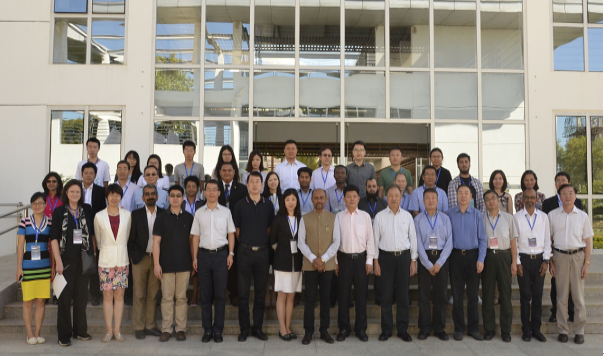
Group photo of the workshop participants.
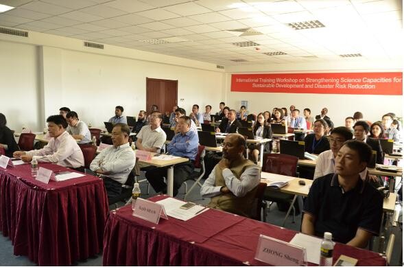
International participants attend the training workshop.