Recently, a Sino-Hungarian project titled “Study on Urban Eco-environment Spatial Information Quantitative Retrieval with Remote Sensing and Validation” passed an acceptance check organized by the Ministry of Science and Technology of China (MOST) with fruitful results.
The project started in 2010 with the support of the International S&T Cooperation Program of China. Prof. MENG Qingyan from RADI, together with his Hungarian partners, Prof. Bela Markus and Prof. Jancso Tamas from the University of West Hungary, are jointly responsible for the project.
The project focuses on the quantitative inversion model of spatial information in Sino-Hungarian urban land surface environments, developing a Sino-Hungarian urban environment remote sensing monitoring information system and laying the foundation for operational monitoring of urban environments with remote sensing.
Both sides benefited greatly from the project in terms of data sharing, model development, technology transfer, software development, publications, personnel cultivation, and international mobility. The cooperation has drawn the attention of the Hungarian Ministry of Rural Development, universities, and institutes.
To implement the project, the RADI research team introduced high-resolution imagery including 0.5-meter orthophotos, Worldview, LIDAR, AISA Eagle II, DEM data, background data, and classification maps of the study area in Hungary as well as the Idrisi remote sensing image processing software. They drew on the experience of the spatial data infrastructure system of Europe (SDI), and introduced some advanced techniques from the Hungarian partners.
The Sino-Hungarian joint research team has solved some key technical problems in remote sensing inversion and validation of urban land surface environmental parameters. The scientists have developed a remote sensing extraction and analysis model library for urban land surface environmental parameters, and have also produced innovative results such as land coverage classification and vegetation leaf area index inversion under complex underlying surface conditions. Moreover, their research has probed into the field of urban greenspace remote sensing and formed a technical framework. They developed a comprehensive urban greenspace index model involving building height, vegetation height, and proximity relationships between buildings and urban greenspace, which can be used for evaluating greening conditions in urban habitats.
The project led to the invention of an “Urban Greenspace Measuring Method Based on High-resolution Remote Sensing Images”. To improve the watershed transformation algorithm based on edge detection, the scientists developed an object-oriented classification method of remote sensing images at the pixel level, and the results were published in the International Journal of Remote Sensing. In addition, the joint research led to the creation of an urban environment remote sensing monitoring system and the construction of a related thematic database.
Through project cooperation RADI has established a sound relationship with its Hungarian partners including the Hungarian Ministry of Rural Development, the Institute of Geodesy, Cartography, and Remote Sensing (FÖMI), Eötvös Loránd University, and the Economic and Engineering Technology University.
Currently, RADI and its Hungarian partners are planning to boost cooperation through joint cultivation of doctoral students, applying for international programs such as HORIZON 2020, and conducting more research on monitoring urban environments.
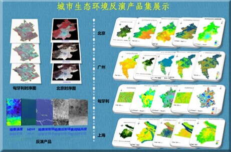
Demonstration of urban eco-environment parameter retrieval.
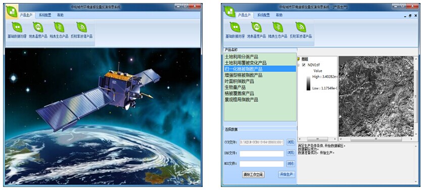
Information system for the quantitative inversion of urban eco-environment parameters based on remote sensing.